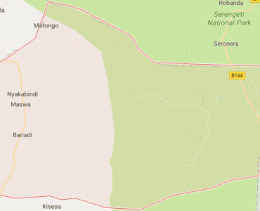
Bariadi District Council was announced as a District Council in 1985. The Council is among six District Councils in Simiyu Region, alongside with Bariadi Town Council, Busega, Itilima, Maswa, and Meatu District Councils.
Under Article 148 of Local Government District Authorities Act of 1982, all Local Government Authorities; including Bariadi, are mandated to play three main functions, these are: maintenance of law, order, and good governance; promotion of economic and social welfare of the people in their areas of jurisdiction and, ensuring effective and equitable delivery of qualitative and quantitative services to the people within their areas of jurisdiction.
Apart from the three main functions, the Local Government Authorities Act, of 1982, stipulates that, all local governments are charged with other functions and duties as follows:
Bariadi District Council is located North of Tanzania and South East of Lake Victoria it lies between Latitude 2015” and 3010’ South of Equator and longitude 33040” and 35010” East of Greenwich. The Council is bordered by Busega Districts (Simiyu Regions) to the West, Bunda and Serengeti Districts (Mara Region) to the North, Maswa Game Reserve to the East, Maswa and Itilima Districts (Simiyu Region) to the South.
The Council covers an area of 5,921.29 Square Kilometers. The land pattern of Bariadi District Council is stretched with plains, hills and valleys, divided into arable land which is suitable for crop production, forest reserves while normal forests/grassland used for grazing and the remaining land is either lying idle for some reason such as soil leaching infestation, or being edges and river beds
Administratively, Bariadi council is divided into 3 divisions, 21 wards,84 villages and 515 hamlets distributed unevenly.
The population of Bariadi District was projected at 293,058 by 2017. Out of these 140,194 are males and 152,864 are females. The average household size is 5 persons; with population growth rate of 2% per annum and population density of 201 people per square kilometer. The dominant ethnic group is Sukuma commonly known as “ntuzu”. Others ethnic groups who migrated into the District include; Chagga, Kurya, Kerewe, Zanaki, Waha, Haya etc settled in trading centers like Nkololo, Dutwa and Ngulyati and some villages.
The District is stretched with plains, hills and valleys, divided into arable land which is suitable for crop production, forest reserves while normal forests/grassland used for grazing and the remaining land is either lying idle for some reason such as soil leaching infestation, or being edges and river beds.
Bariadi district in most parts experiences’ bimodal rainfall patterns, the short rains falling from October to December and the long rains pours between March and May. While, dry periods spell from January to end of February and between June and end of September. The District’s average annual rainfall ranges between 700mm-950mm pa. The temperature in the district ranges from 290C and 190C.
Economic activities in Bariadi District are mainly farming and livestock keeping as well as informal sector activities. The informal sector, which employs few people and predominant in township areas, encompasses trade activities and artisan undertakings.


Bariadi
Anuani: 109-Bariadi
Simu: 028 2700012
Simu: +255683705815
Barua Pepe: info@bariadidc.go.tz
Copyright ©2019 Bariadi District Council . All rights reserved.